What is the Nesciobrug?
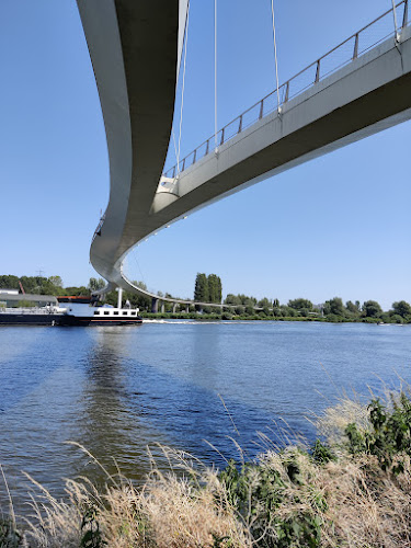
The Nesciobrug, or Nescio Bridge, is a 780-meter bridge for cyclists and pedestrians over the Amsterdam-Rhine Canal in Amsterdam-Oost. It opened in 2006. The bridge links IJburg and Diemerpark on the north bank with Science Park, Watergraafsmeer and the rest of Amsterdam-Oost on the south side. It is free to cross, open around the clock and off-limits to mopeds and scooters.
Its 163.5-meter main span hangs from a single cable strung between two pylons. When it opened, that made it the longest single-cable suspension bridge in the Netherlands, and it was the country’s first suspension bridge built only for people on bikes and on foot. Locals often call it the Palingbrug, or eel bridge, after its long, curving shape.
You’ll find it right next to the Zeeburgerbrug, which carries the A10 ring road over the same canal. In Amsterdam’s official bridge register it is bridge no. 2013.
| Nesciobrug fact | Detail |
|---|---|
| Total length | About 780 meters, including approach ramps |
| Main span | 163.5 meters between the pylons |
| Clearance over the water | About 10 meters |
| Opened | 9 April 2006 for pedestrians, 7 June 2006 for cyclists |
| Designers | WilkinsonEyre (architect Jim Eyre) with engineers Arup and Grontmij |
| Cost | About 16.5 million euros |
| Who can use it | Cyclists and pedestrians only |
| Opening hours and price | Open 24 hours, free |
Why the bridge is named after Nescio
Nescio was the pen name of Jan Hendrik Frederik Grönloh (1882–1961), an Amsterdam office worker who wrote stories on the side. The name is Latin for “I don’t know.” His best-known works include De uitvreter, Titaantjes and Dichtertje, and his reputation grew enormously after his death.
In his Natuurdagboek (nature diary), Nescio recorded countless walks in and around Amsterdam and Diemen. He could be rude about Diemen’s houses, but he wrote warmly about the water and landscape. Those pages gave the Diemerzeedijk, the dike where the bridge lands on the IJburg side, a lasting place in Dutch literature.
Design and engineering
Suspension bridges are rare in the Netherlands because the soft Dutch soil makes it hard to anchor main cables into the ground. The Nesciobrug gets around this with a self-anchored design: its single cable is fixed to the bridge structure itself. According to Arup, the curve of the deck follows the natural line a cyclist would ride.
The deck’s cross-section changes along its length. It is a deep triangle at midspan, where stiffness matters most, and flattens out towards the ends, where it merges into the concrete approaches. The angled sides make the bridge less visible to radar, so it doesn’t interfere with shipping on the canal. Arup also tested the design in a wind tunnel to check it would stay stable in strong wind.
At both ends the deck splits in two. Cyclists take the long, gently sloping ramps, while pedestrians take a shorter route that ends in a spiral staircase. The split also makes the structure stiffer. Since the 2021 resurfacing, the cycle lane has been red asphalt and the footpath almost black, so it’s easy to see which side is yours.
The spiral cycle ramp at the southern end is the part most people remember. The Amsterdam branch of the Dutch cyclists’ union measured a 12-meter climb with an average gradient of 3.19%, although the start of the slope reaches about 7% in places. The spiral turns more than 270 degrees with a radius of about 35 meters, and Bicycle Dutch has a good ride-through video if you want a preview.
You may feel the deck move slightly under a crowd of walkers. Three tuned mass dampers limit that: a 10,000 kg damper at midspan and two 1,500 kg dampers at the quarter points.
How it was built
The 510-tonne main deck was built in Rotterdam and shipped to Amsterdam, a trip that took two days. It was lifted into place on 9 July 2005, which meant closing the Amsterdam-Rhine Canal to shipping for half a day. The bridge opened to pedestrians on 9 April 2006 and to cyclists on 7 June 2006.
The City of Amsterdam commissioned the bridge, and its location owes something to local politics. Diemen opposed the development of IJburg and wouldn’t cooperate on a cycle link, so the whole crossing was kept just inside Amsterdam’s boundary.
This isn’t the first link across the canal here. From 1951, a diesel-powered rail ferry carried traffic across from the Veerhuis on the Ouddiemerlaan, riding on wheels along a track about six meters below the water. It made its last crossing in 1972, when the canal was widened to 100 meters. For more than three decades after that, people had to detour via other bridges.
In 2006 the Nesciobrug won the Dutch Nationale Staalprijs (national steel award) in the infrastructure category, with the jury praising its elegance. In 2015 PostNL put it on a stamp in a series of ten exceptionally designed bridges.
Tips for visiting
- Cross it rather than just looking at it. From the top of the span, about 10 meters above the water, you look out over the canal and can watch cargo ships pass underneath.
- Go early or late in the day if you want photos. Low sun brings out the shape of the steel, and quieter hours mean fewer bikes in the frame.
- Bring an extra layer. The bridge is exposed, and this side of Amsterdam near IJburg is often windier and cooler than the canal belt.
- Keep to your lane. Cyclists use the red lane and walkers the darker one; stepping onto the red side at the wrong moment is the quickest way to annoy Amsterdam commuters.
- Visit in any season. It’s lovely on a clear summer evening, but in winter the bare trees around the approaches make the curves of the ramps easier to see.
Make a half-day of it by adding Diemerpark on the north side. Opened in 2004 on a former landfill, it covers about 90 hectares, roughly twice the size of Vondelpark, and has a small city beach; see our guide to swimming spots in Amsterdam before you swim. The quiet waterways around IJburg are also where Amsterdam filmed its first otter in about 50 years, which we cover in our guide to Amsterdam wildlife.
How to get to the Nesciobrug
Cycling is the easiest way, because the bridge was built as a shortcut for bikes between IJburg, Diemen, Watergraafsmeer and the rest of Amsterdam-Oost. From the city center, ride east through Oost and follow the signs towards IJburg or Diemerpark. Our Amsterdam Oost neighborhood guide covers the routes and places along the way.
- North side by tram: take tram 26 from Amsterdam Centraal towards IJburg and get off at Diemerparklaan. Walk south through Diemerpark to the Diemerzeedijk and the bridge’s northern approach.
- South side by train: go to Amsterdam Science Park station, then walk or cycle to the spiral ramp at the southern end.
- By moped or scooter: not allowed. The bridge is for walkers and cyclists only, and motorized two-wheelers risk a fine.
Frequently asked questions
Can you ride a moped or scooter over the Nesciobrug?
No. The bridge is only for people walking and cycling, and riders of motorcycles, mopeds or scooters risk a fine.
Does it cost anything to cross the Nesciobrug, and is it open at night?
Crossing is free, and the bridge is a public route that stays open 24 hours a day.
Why is the Nesciobrug called the Palingbrug?
Paling is Dutch for eel. Locals use the nickname because the long, curving bridge looks a bit like one.
Can ships pass under the Nesciobrug?
Yes. It is a fixed bridge with about 10 meters of clearance, so cargo ships on the Amsterdam-Rhine Canal pass underneath without it having to open.