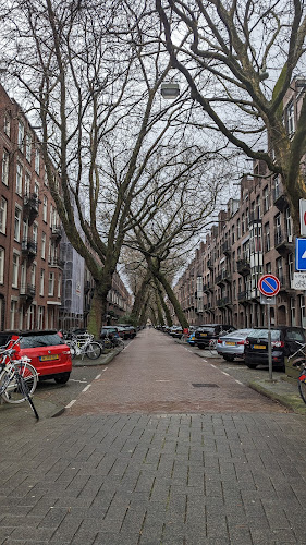
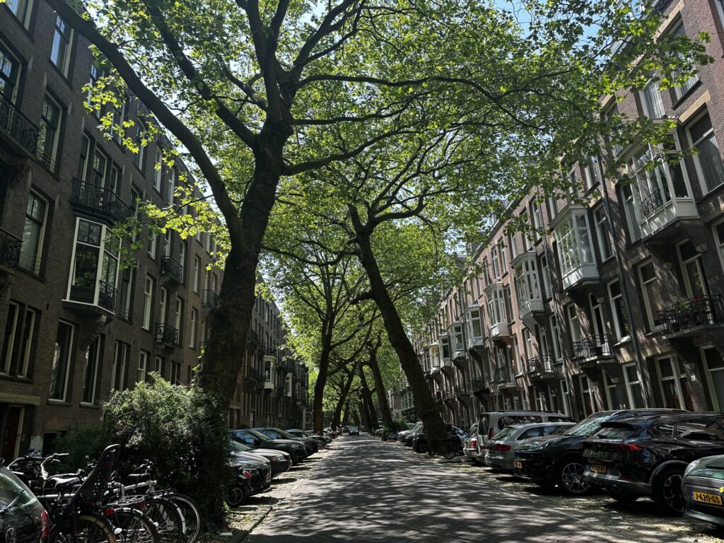
The street people mean when they search for Amsterdam’s tree tunnel is Lomanstraat, a residential street in the Willemspark quarter of Amsterdam-Zuid, Netherlands, just south of the Vondelpark. Two rows of plane trees, planted around 1927, lean in from either kerb until their trunks and branches cross overhead in rough X shapes, closing the road under a canopy.
It is an ordinary public street: no gate, no ticket, no opening hours, and nothing to buy. The nearest trams are on line 2. The canopy is at its best from late September to early November, and easiest to read in winter, when the bare crossed trunks are fully exposed.
Lomanstraat tree tunnel at a glance
| What it is | A residential street in Amsterdam whose two rows of street trees have grown together into a closed canopy |
| Where | Lomanstraat, Willemspark, Amsterdam-Zuid, Netherlands (approx. 52.3516, 4.8611). It runs between the Cornelis Krusemanstraat and the Valeriusstraat |
| The trees | Plane trees (platanen), as identified on the street by tree expert Hans Kaljee for AT5 |
| Planted | Around 1927, upright, according to Kaljee. The lean came later |
| Also called | The Lomanstraat tree tunnel, the green tunnel, the X trees |
| Cost | Free. It is a public street |
| Opening hours | None. Open at all times |
| Best months | Late September to early November for autumn colour; December to March for the bare crossed trunks |
| Best light | Two to three hours after sunrise, or the same before sunset |
| How long to allow | 10 to 30 minutes, depending on how much you photograph |
| Nearest trams | Tram 2: Zeilstraat, Amstelveenseweg or Haarlemmermeerstation; Valeriusplein on the Vondelpark side |
| Crowds | Low. It is a lived-in street with nothing there to serve visitors |
Where is Lomanstraat in Amsterdam?
Lomanstraat is in the Willemspark neighbourhood of the Amsterdam-Zuid borough, on the far side of the Vondelpark from the city centre. The City of Amsterdam draws Willemspark’s boundaries along the Amstelveenseweg, the Vondelpark, the Koninginneweg, the Emmastraat, the Noorder Amstelkanaal, the Hendrik Jacobszstraat and the Cornelis Krusemanstraat. Lomanstraat sits inside that block and runs between the Cornelis Krusemanstraat and the Valeriusstraat.
Many guides get the directions wrong here. This corner of the Oud-Zuid district is closer to the Amstelveenseweg than to the museum quarter, so the tram corridor you want is the western one, not the Beethovenstraat side.
| Getting there | Detail |
|---|---|
| Tram | Journey planners list Zeilstraat, Amstelveenseweg and Haarlemmermeerstation as the closest stops. All are on tram 2. Valeriusplein, also tram 2, is the nearest stop on the Vondelpark side |
| A stop to ignore | Gerrit van der Veenstraat, on trams 5 and 24, is a real stop but sits on the eastern side of Oud-Zuid, outside Willemspark. No journey planner lists it among Lomanstraat’s nearest stops |
| Paying for the tram | Tap in and out with a contactless bank card or phone. See our OVpay guide |
| On foot | A short walk from the Vondelpark’s southwestern end. Willemspark begins at the park boundary |
| By bike | The obvious way. A cycle route runs under the canopy, and riders use it to get somewhere, so do not treat it as a viewing platform |
| By car | Do not. This is paid residential parking and the street is narrow |
The canopy is not uniform along the whole street. The crossing is tightest where the trees are largest and the buildings closest, so walk the full length and turn around a few times rather than stopping at the first corner.
What kind of trees are they?
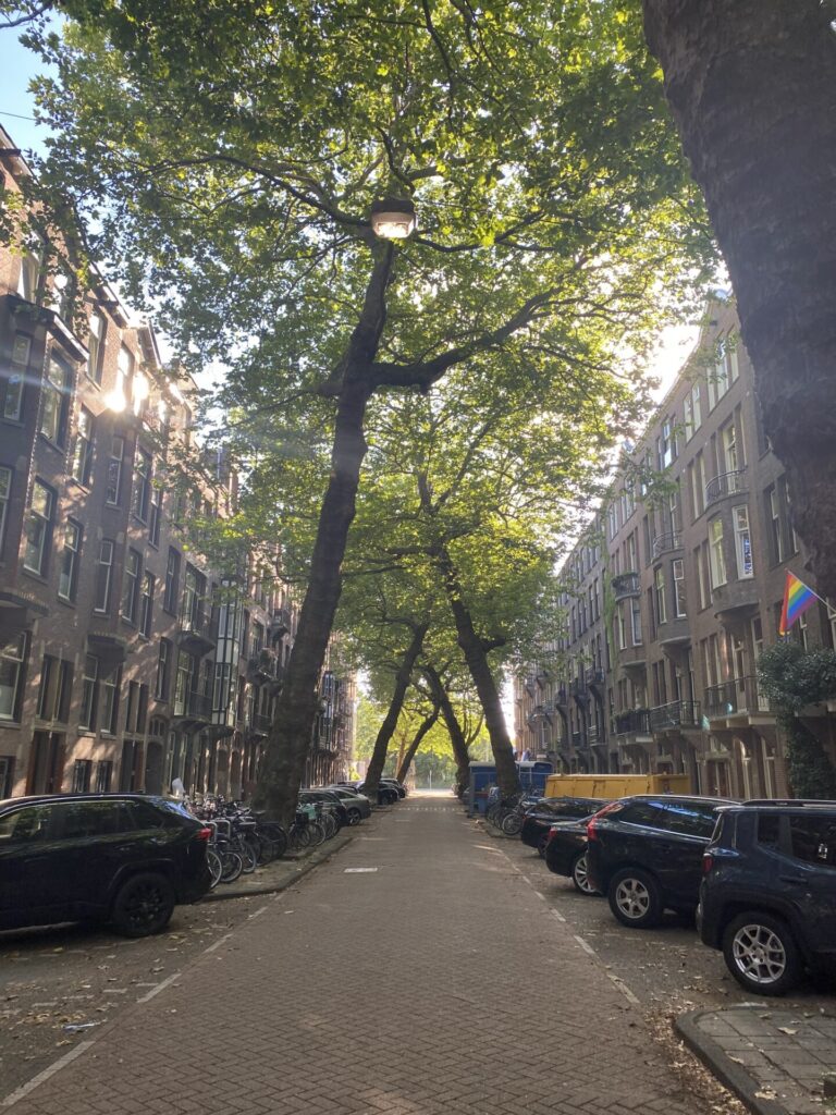
Plane trees. In an October 2025 episode of AT5’s De Straten van Amsterdam, tree expert Hans Kaljee stands on the street and identifies them as platanen, the Dutch word for plane trees. Joods Amsterdam, a local history site that documents the street’s residents, describes de Lomanstraat the same way: known for the platanen that grow at an angle toward each other.
Other pages name other trees. Rove.me and the German guide Mr. Amsterdam call them honey locust (Gleditsia triacanthos), and social captions have called them chestnuts and even elms. None of those claims comes with an on-site identification, so we treat the plane-tree answer as the reliable one. We have not checked the exact botanical hybrid of each individual tree, which is why this page says plane tree and stops there.
| Tree | Status for Lomanstraat | How you would know on the spot |
|---|---|---|
| Plane tree (Platanus) | Identified on camera by tree expert Hans Kaljee (AT5); also named by Joods Amsterdam and most English-language coverage | Bark that flakes off in patches, leaving a cream-and-olive camouflage pattern. Big single leaves with pointed lobes. Bristly round seed balls hanging on stalks through winter |
| Honey locust (Gleditsia triacanthos) | Claimed by Rove.me and Mr. Amsterdam; no on-site identification given | Dark, deeply ridged bark. Leaves made of many small leaflets in rows, so the shade is dappled rather than solid. Long flat brown pods on the ground in autumn |
| Horse chestnut (Aesculus hippocastanum) | Claimed in some listings and social captions; no identification given | Leaves like a hand, five to seven leaflets spreading from one point. Conkers in spiky green cases in autumn. Fat sticky buds in winter |
If you want to look up individual trees, the City of Amsterdam publishes a public map of the trees it manages, searchable by street and showing species: maps.amsterdam.nl/bomen. The city notes that the map is not updated in real time, so treat it as a record of municipal data rather than a live inventory.
Why do the trees lean and cross?
They grew that way. In the AT5 interview, Kaljee explains that records put the planting at around 1927, that the young trees were planted upright, and that they leaned toward the light over the decades that followed. The houses on both sides were already standing, so the only reliable opening in the sky was the strip directly above the road. The crowns pushed toward it, the trunks followed, and the two rows eventually met in the middle.
A certified tree inspector quoted in recent travel coverage adds that the trees have been checked and are structurally sound, with healthy root systems and no risk attached to the lean.
Two further theories circulate. Neither is documented, and neither replaces the light explanation.
- Compacted soil. A German guide to the street suggests that traffic compacts the soil under the road, so roots on the road side do worse than roots on the pavement side. That would add a below-ground push to the above-ground pull of the light. It is plausible, but we found no measurement of it on this street.
- Deliberate training. Some residents say municipal gardeners trained the young trees into a shaped avenue, as was sometimes done in Dutch cities in the early 20th century. The evidence is oral. Kaljee’s account of trees planted upright and leaning later does not support it.
Did Nazi officers really save these trees?
This story brings the street most of its clicks. Part of it is documented and part of it is not.
The documented part: during the Hongerwinter of 1944 to 1945, the German blockade cut food and fuel to the occupied western Netherlands. Gas and electricity failed, the winter was severe, and around twenty thousand people died. Amsterdammers desperate for firewood cut down street trees and park trees and burned them, along with railway sleepers and the woodwork of emptied houses. Contemporary accounts describe whole avenues disappearing.
The undocumented part: the claim that Lomanstraat kept its trees because senior German officers lived on it, and nobody dared cut wood outside their doors. That circulates as neighbourhood oral history, most visibly in a Reddit thread that ranks near the top for this street and in the travel articles that repeated it. We have not found a primary source. No archive, memoir or city record we could find names Lomanstraat.
There is a simpler possibility. If the trees went in around 1927, they were only about 17 years old in the Hunger Winter, and Kaljee offers their smaller size then as another explanation for their survival. That is a possibility, not proof.
What is beyond dispute is that the occupation was run from a few streets away. The Sicherheitsdienst and the Zentralstelle für jüdische Auswanderung, the office that organised the deportation of Amsterdam’s Jews, worked out of two former school buildings on the Euterpestraat, in this same part of Oud-Zuid. On 18 May 1945 the city council renamed that street after Gerrit van der Veen, the sculptor and resistance fighter executed in 1944. The tram stop some guides wrongly send you to for Lomanstraat carries his name.
The street’s own wartime history is documented, and it concerns its residents. Joods Amsterdam records Jewish families who lived here, among them Menno Ratzker, born in 1938 and living at number 31. His family survived the Holocaust by going into hiding in the Dutch countryside when the deportations began in mid-1942. If you want a true wartime story about Lomanstraat, that is one.
When is the best time to visit Lomanstraat?
Late September to early November if you want the gold, with October the safest single month to aim for. Most pages covering the street agree on that window. Outside it, the street is still worth the detour, for different reasons.
| Season | What the canopy does | Worth going? |
|---|---|---|
| Spring (Mar to May) | New leaves fill in the branch lattice. The crossings still show through the thin foliage | Yes, and it is the quietest time. The best compromise if you want the structure and the green at once |
| Summer (Jun to Aug) | Closed and solid. Deep shade and strong dappled light on the road | Yes for the tunnel effect, less so for the X shapes, which the leaves hide |
| Autumn (late Sep to early Nov) | Fall foliage in gold and bronze overhead, leaf litter underfoot, the branch structure re-emerging | The peak. Also the only time you will share the street with other photographers |
| Winter (Dec to Mar) | Bare branches. The crossed trunks are fully exposed against the sky | Underrated. If you came for the X shapes rather than the colour, this is the season |
The autumn peak moves by a couple of weeks from year to year with the weather, so treat late September as the earliest edge rather than a date to book around. A weekday morning beats a weekend afternoon in any season.
Which neighbourhood is this, and who built it?
Lomanstraat is often credited to Plan Zuid, Hendrik Petrus Berlage’s expansion plan for southern Amsterdam. Much of the recent travel coverage repeats that, and this page once did too. It is wrong, and correcting it also fixes the dates.
| Willemspark (Lomanstraat) | Plan Zuid | |
|---|---|---|
| Planned by | J.G. van Niftrik, 1881, as a villa park around ponds continuing from the Vondelpark; laid out to a design by L.P. Zocher, who also designed the Vondelpark | Hendrik Petrus Berlage |
| Built | Built out from 1902 and named after King Willem III | Adopted by the city in 1917 |
| Housing | Mostly upper-floor apartments and townhouses built between 1906 and 1914 | Largely 1920s and 1930s, much of it Amsterdam School |
| Where | Between the Vondelpark and the Koninginneweg, west toward the Amstelveenseweg | The districts further south and east, beyond the Noorder Amstelkanaal |
The houses came first. The flanking blocks went up between 1906 and 1914, and the city archive holds a picture postcard of Lomanstraat dated 1910. The present trees followed around 1927, according to Kaljee. So when the young trees went in, tall buildings were already shading them from both sides, and that is the setting that makes the lean make sense. It also means the trees are close to 100 years old, not the “more than a century” that many captions claim.
Berlage and the Amsterdam School are still the right context for the wider south of the city, and Zuid is full of both. They just are not the story of this street.
How to take Lomanstraat photos that don’t look like everyone else’s
Stand in the middle of the road, point down the street, and the vanishing point does the work. Nearly every photo of Lomanstraat looks exactly like that, which is worth knowing before you cross the city for it.
- Go two to three hours after sunrise or before sunset. Low sun filtering through the canopy is the point, and midday flattens it.
- Walk the street twice and look back. From some positions the trunks read as knotted rather than crossed, which almost nobody shoots.
- Put a person or a passing cyclist in the frame. Without one, the trees lose their scale.
- Shoot straight up. The lattice where the two rows interlock is the real subject, and the street-level view buries it.
- Overcast is not a write-off in autumn. Flat light saturates the leaf colour and removes the hard shadows that break up the road surface.
- Check behind you before standing in the road. Cyclists use the street and they are moving.
Is it busy, and how should you behave?
It is not busy. The street is all over Instagram and TikTok under #lomanstraat, and AT5 notes that hundreds of photos of the crossing plane trees appear every day. Even so, it stays a residential street with little visitor traffic. There is no cafe, bench, sign or bin. Autumn weekend afternoons are the busiest it gets, and that still means a handful of people with cameras.
That is exactly why you should be careful with it. These are front doors and ground-floor windows.
- Keep your voice down, especially early and late.
- Do not stand in doorways, and do not photograph into windows or at residents.
- Give way to cyclists rather than making them swerve around a tripod.
- Leave the trees alone. No climbing, no hanging off low branches, no tree guards as props.
- Take your litter with you. There is nowhere to put it.
On accessibility: the pavements are flat, paved and kerbed in the normal Amsterdam way, and the street is level throughout, so it is manageable with a wheelchair or a pushchair. There is no seating, shelter or public toilet anywhere on the street.
What’s near Lomanstraat?
Lomanstraat takes ten minutes. It works best as a detour, and everything below is walkable or one short tram ride away.
- Vondelpark begins at the neighbourhood boundary and is the obvious pairing. Our guide to Amsterdam’s best picnic spots covers where to sit and what the barbecue rules are.
- The museum quarter is a walk or a short tram ride east: the Rijksmuseum, the Van Gogh Museum, the Stedelijk and the Concertgebouw.
- For quieter green space than the Vondelpark, Beatrixpark and Sarphatipark are both in Zuid and both far less crowded.
- If leaning things are why you came, the crooked houses of Amsterdam are the built version of the same idea. The canal guide covers the streets people usually mean when they ask which one is the prettiest.
- Amsterdam’s street trees hold more wildlife than they seem to. Our guide to wildlife in Amsterdam covers what lives in them, including the parakeets you will hear before you see.
Frequently asked questions
Which street in Amsterdam is known for its plane trees that form a natural tunnel over the road?
Lomanstraat in Amsterdam, in the Willemspark neighbourhood of Amsterdam-Zuid, just south of the Vondelpark. Two rows of plane trees, planted around 1927, lean in from opposite kerbs and cross overhead. It is a public street with no entry fee and no opening hours.
What type of trees are on Lomanstraat?
Plane trees. Tree expert Hans Kaljee identified them on the street as platanen (plane trees) for AT5 in 2025. Some travel pages call them honey locust or chestnut, but those claims come without an on-site identification. Plane trees have flaking, cream-and-olive patched bark, which is the quickest check.
Why do the Lomanstraat trees lean?
According to Kaljee, the trees were planted upright around 1927 and leaned over the decades toward the only reliable light: the strip of sky above the road between the tall houses. Theories about compacted soil or deliberate training by gardeners circulate, but neither is documented.
When is the best time to visit the Lomanstraat tree tunnel?
Late September to early November for autumn colour, with October the safest month. December to March is better for seeing the bare crossed trunks. In any season, go two to three hours after sunrise or before sunset.
Did the trees survive the Second World War because Nazi officers lived there?
That is unverified. Amsterdammers did cut down street trees for firewood during the Hunger Winter of 1944 to 1945, but no primary source we could find says Lomanstraat was spared because German officers lived on it. Kaljee suggests the trees, then only about 17 years old, may simply have been too small to be worth cutting.
Is Lomanstraat part of Berlage’s Plan Zuid?
No, although it is often described that way. Lomanstraat is in Willemspark, planned in 1881 by J.G. van Niftrik, laid out to a design by L.P. Zocher and built out from 1902, with most housing from 1906 to 1914. Berlage’s Plan Zuid was adopted in 1917 and shaped the districts further south and east.
How do I get to Lomanstraat by public transport?
Take tram 2. Journey planners list Zeilstraat, Amstelveenseweg and Haarlemmermeerstation as the nearest stops, with Valeriusplein closest on the Vondelpark side. Tap in and out with a contactless card or phone. The Gerrit van der Veenstraat stop on trams 5 and 24 is on the other side of Oud-Zuid.
Checked against: AT5’s October 2025 De Straten van Amsterdam episode on Lomanstraat and its interview with Hans Kaljee, Joods Amsterdam’s Lomanstraat page, the City of Amsterdam’s neighbourhood and monument documentation for Willemspark and the Vondelpark, the city’s public tree map, GVB and Dutch journey-planner stop data, Joods Monument and Amsterdam City Archives material on the Euterpestraat, and 2025 to 2026 travel coverage of the street.