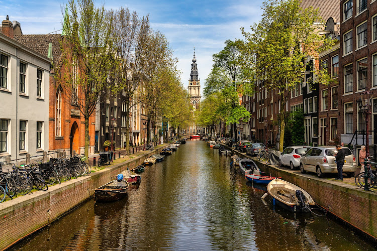
The Staalmeestersbrug (bridge 227) is a small white drawbridge in central Amsterdam, where Staalstraat crosses the Groenburgwal canal. Stand on it and you look straight down the water at the tower of the Zuiderkerk, the view Claude Monet painted around 1874. It is free, open at all hours, and closed to cars since 2021, so you can stop halfway across without traffic behind you. The city plans to replace the bridge between 2027 and 2029, so the structure you cross today has a short remaining life.
Staalmeestersbrug at a Glance
| Official name | Staalmeestersbrug, also catalogued as brug 227 |
| Where | Staalstraat at the Groenburgwal, Amsterdam-Centrum |
| Coordinates | 52°22'05.6"N, 4°53'51.7"E |
| Type | Wooden drawbridge (Dutch: ophaalbrug) |
| Present bridge | Construction began 9 July 1928; deck renewed 1973 |
| Protected status | Municipal monument since 1995 |
| Access and cost | Free, no opening hours. Walking and cycling only; closed to cars since 2021 |
| Known for | The Zuiderkerk view Monet painted around 1874 |
| Best time | First hour after sunrise for still reflections; last hour before sunset for warm light |
| Planned works | Bridge replacement 2027–2029; Groenburgwal quay walls 2029–2031 |
Why Is the View From the Staalmeestersbrug So Famous?
Because the bridge lines up a narrow canal, a row of gabled houses and a church tower in a single sightline. The Groenburgwal is one of the shortest and quietest canals in the centre, and from the middle of the bridge the Zuiderkerk tower closes the view at the far end. Claude Monet, who painted in the Netherlands in the 1870s, worked that composition into The Zuiderkerk, Amsterdam (Looking up the Groenburgwal), an oil painting of about 1874 measuring 65.4 by 54.5 centimetres.
One practical point that trips up visitors: the painting is not in Amsterdam. It belongs to the Philadelphia Museum of Art. What you can do here is stand where the view was composed, which costs nothing and takes about two minutes off the main tourist route.
Why Is It Called the Staalmeestersbrug?
The name comes from the staalmeesters, the wardens of the Amsterdam drapers' guild who inspected textile samples (in Dutch, stalen) at the guild hall on this street in the 17th century. The same officials gave Staalstraat its name. Rembrandt van Rijn painted six of them in 1662 in The Syndics of the Drapers' Guild, known in Dutch as De Staalmeesters, which hangs in the Rijksmuseum. So the bridge, the street and one of the most reproduced group portraits in Dutch art all trace back to the cloth trade that ran through this block.
How Old Is the Bridge, and How Long Will It Be There?
A crossing has existed at this spot for centuries. It appears on Pieter Bast's map of Amsterdam from 1599, and Balthasar Florisz van Berckenrode's 1625 map already shows a drawbridge over the Groenburgwal. The bridge you cross today is much younger: its identical predecessor of 1887 had worn out by 1928, and construction of the replacement began on 9 July 1928. The deck was renewed in 1973, and the bridge has been a municipal monument since 1995.
That protected status has not stopped it from failing. The City of Amsterdam reports that the western abutment and the adjoining Groenburgwal quay wall are in poor condition: the structures are shifting towards the water, there is an opening below the waterline through which sand and soil are washing out, the masonry has large cracks, and foundation piles under the quay are tilting. Cars were barred from the bridge in 2021 as a stopgap while a permanent fix was planned.
The permanent fix is replacement. The city has scheduled the Staalmeestersbrug to be replaced between 2027 and 2029, with the Groenburgwal quay walls following from 2029 to 2031. Expect construction fencing, closures and diversions on Staalstraat during those years. If you want the Monet view without a building site in it, the window is now.
How Does It Compare With Amsterdam's Other Famous Bridges?
The Staalmeestersbrug is the quiet, narrow-canal option. The Amstel bridges are bigger, busier and better after dark. If you only have time for one bridge stop, pick by what you want to photograph.
| Bridge or view | Where | What you see | Traffic | Best time |
|---|---|---|---|---|
| Staalmeestersbrug | Staalstraat at the Groenburgwal | Zuiderkerk tower framed down a narrow canal | Walking and cycling only | Early morning, for still reflections |
| Magere Brug | River Amstel at Kerkstraat | White wooden drawbridge, outlined in white lights after dark | Walking and cycling only since 2003 | After sunset |
| Blauwbrug | River Amstel, between Waterlooplein and Rembrandtplein | Ornate 1883 stone bridge with ship's-bow piers and imperial crowns | Road traffic and pedestrians | Blue hour, looking towards the Magere Brug |
| Seven Bridges viewpoint | Reguliersgracht at Herengracht | Seven arched canal bridges receding in one sightline | Road traffic on the quays | After dark, when the arches are lit |
The Magere Brug was rebuilt in its present form in 1934 and has been limited to pedestrians and cyclists since 2003. The Blauwbrug dates from 1883 and was built in time for the World Colonial Exhibition, its decoration borrowed from the ornate stone bridges over the Seine in Paris. For a wider tour of the waterways these bridges cross, see our guide to the Amsterdam canals.
When Is the Best Time to Photograph It?
The first hour after sunrise is the strongest slot. The Groenburgwal is sheltered, so the water sits still enough to mirror the houses, and Staalstraat is empty enough to set up without stepping aside every few seconds. The last hour before sunset gives warmer light on the Zuiderkerk tower but more people on the bridge, because it sits on a well-walked route between the Rokin and Waterlooplein.
- Shoot from the middle of the span, aiming north-east along the canal, to put the tower in the centre of the frame.
- Parked bikes line both railings. Either include them as foreground or step to the far side of the bridge deck.
- The bridge still opens for boats. If the deck is raised, wait a few minutes rather than walking around.
- Winter mornings give mist on the water; summer evenings give reflections of lit windows.
Can You Still Put a Love Lock on the Bridge?
No, and locks attached here are cut off. The Staalmeestersbrug did collect padlocks for years, and it is still the bridge most often named when people search for a love lock spot in Amsterdam. In 2015 the city decided to clear locks from around 60 historic bridges in the centre, and new ones are removed on the same basis: the added metal and weight damage railings and decking on protected structures. Given that this bridge is a municipal monument already scheduled for replacement because of structural failure, leaving a lock is the least useful thing you can do here.
What Else Is Nearby?
- Zuiderkerk, the tower you photograph from the bridge, is a two-minute walk. Built between 1603 and 1611 to a design by Hendrick de Keyser, it was the first church in Amsterdam built for Protestant worship. It no longer holds services and is used for events and exhibitions. Tower climbs run in the summer months, typically afternoons from Wednesday to Saturday; check the current schedule before you go.
- The Rembrandt House Museum is about five minutes away on Jodenbreestraat, in the house where Rembrandt lived and worked.
- Waterlooplein flea market sits just beyond it, and the Rokin and Muntplein are the same distance in the other direction.
- Staalstraat itself is a short run of small shops and cafes, which is why the bridge is busier at midday than the canal suggests.
How to Get There
There is no car access, so plan to arrive on foot, by bike or by public transport. The nearest metro stations are Rokin and Waterlooplein, both under ten minutes' walk, and trams stop at the Rokin and Muntplein. If you are paying for trams and metro with a bank card or phone rather than a paper ticket, our OVpay guide covers how tapping in and out works and what a trip actually costs.
FAQ: Common Questions
Where exactly is the Staalmeestersbrug located?
The Staalmeestersbrug is in Amsterdam-Centrum, where Staalstraat crosses the Groenburgwal canal. Its coordinates are 52°22'05.6"N, 4°53'51.7"E. The nearest metro stations are Rokin and Waterlooplein, both under ten minutes on foot.
Is this the bridge in Monet's painting, and can I see the painting in Amsterdam?
Monet painted the view up the Groenburgwal towards the Zuiderkerk tower around 1874, and you can stand where that composition was framed. The painting itself is not in Amsterdam: The Zuiderkerk, Amsterdam (Looking up the Groenburgwal) belongs to the Philadelphia Museum of Art.
Can you drive or cycle across the Staalmeestersbrug?
Cycling and walking are fine. Cars have been barred since 2021, after the city found the western abutment and the neighbouring quay wall to be in poor condition. The deck still lifts for boats, so you may have to wait a few minutes to cross.
Is the Staalmeestersbrug the love lock bridge in Amsterdam?
It is the bridge most often named as one, but locks do not stay. Amsterdam cleared padlocks from around 60 historic bridges in the city centre in 2015 and keeps removing new ones, because the metal damages railings on protected structures.
Is the bridge going to be replaced?
Yes. The City of Amsterdam has scheduled the Staalmeestersbrug for replacement between 2027 and 2029, with the Groenburgwal quay walls replaced from 2029 to 2031. Expect works, fencing and diversions on Staalstraat in those years.
Last Updated: July 2026 (What We Verified)
Checked in July 2026 against the City of Amsterdam bridge programme, the Dutch record for bridge 227, and the Philadelphia Museum of Art catalogue entry for the Monet. Three details changed from the previous version of this page. The deck renewal is dated 1973, not 1964. The bridge has been closed to cars since 2021 and is scheduled for replacement between 2027 and 2029, which was not previously noted. And the love lock line has been corrected: Amsterdam removed locks from roughly 60 centre bridges in 2015 and continues to cut off new ones, so attaching one is not an option here. Two claims we could not verify, a 4-metre span and a height of 1.22 metres above the water, have been removed rather than repeated.
Helpful Links
- Amsterdam canal cruise routes
- City of Amsterdam: Staalmeestersbrug works and replacement plan
- Bridge 227 map location
- Browse accommodation near the Staalmeestersbrug
Affiliate disclosure: the accommodation link above is an affiliate link. If you book through it we may earn a commission at no extra cost to you. It does not affect what we recommend or what we report about this bridge.